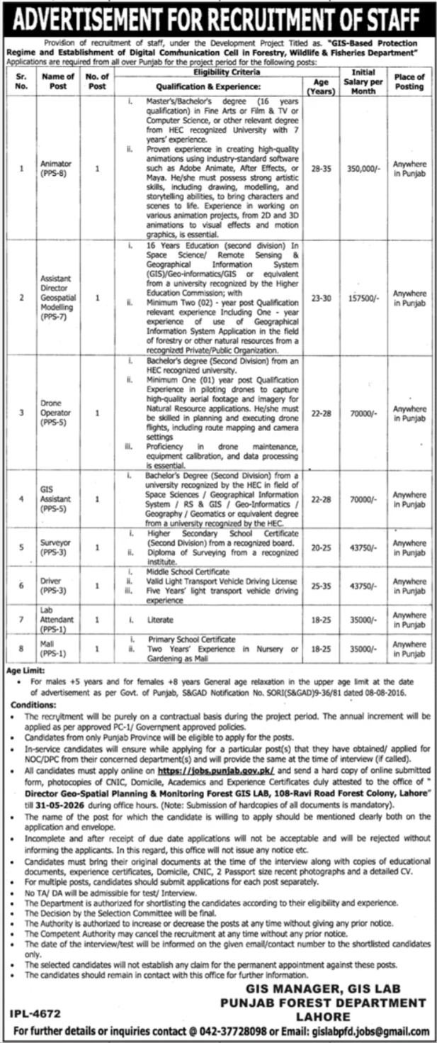
The Forestry, Wildlife & Fisheries Department, Government of the Punjab, has announced multiple career opportunities under its new development project titled “GIS-Based Protection Regime and Establishment of Digital Communication Cell.” This project aims to modernize the monitoring and protection of Punjab’s natural resources using advanced geospatial technology and digital communication tools.
Applications are invited from eligible candidates across the Punjab Province to fill these positions on a contract basis for the project period. These roles offer competitive salaries (up to 350,000/- PKR) and a chance to work on high-impact environmental conservation projects. Candidates with a strong background in GIS, media production, and field operations are highly encouraged to apply.
Vacant Positions and Eligibility Criteria
The following positions are available. Please note that the place of posting for all these roles is “Anywhere in Punjab” based on project requirements.
| Sr. | Name of Post | PPS | Quota | No. of Posts | Descriptions | Eligibility Criteria |
| 1 | Animator | 08 | Punjab | 01 | The Animator will be the creative lead for the Digital Communication Cell, responsible for producing high-quality visual content to raise awareness about forestry and wildlife conservation. This role involves conceptualizing and executing 2D and 3D animations, motion graphics, and visual effects using industry-standard software like Adobe Animate or Maya. The specialist must possess strong storytelling and artistic abilities to bring complex environmental concepts to life through digital media. Working closely with the technical teams, the Animator will create educational videos and promotional material that help the department communicate its protection regimes and conservation success stories to the general public and stakeholders effectively. | Master’s/Bachelor’s (Fine Arts, Film & TV, CS) with 7 years’ experience in high-quality animations. |
| 2 | Assistant Director Geospatial Modelling | 07 | Punjab | 01 | The Assistant Director of Geospatial Modelling is a technical leadership position focused on the analytical side of forest protection. The role involves utilizing Remote Sensing (RS) and Geographical Information Systems (GIS) to develop models for natural resource management and monitoring. The officer will be responsible for interpreting satellite imagery, performing spatial analysis, and managing geospatial databases to track changes in forest cover or wildlife habitats. This position requires a professional who can translate complex spatial data into actionable insights for the department’s protection regime. Experience in applying GIS technology specifically within the forestry or natural resource sector is highly prioritized for this critical planning role. | 16 Years Education (Space Science, RS & GIS, Geo-informatics) with 2 years’ relevant experience. |
| 3 | Drone Operator | 05 | Punjab | 01 | The Drone Operator serves as the “eyes in the sky” for the department, providing essential aerial surveillance and high-resolution imagery for natural resource monitoring. This role requires technical proficiency in piloting advanced UAVs to capture aerial footage and imagery used for mapping and protection activities. The operator must be skilled in flight planning, executing route mapping, and managing camera settings to ensure data accuracy. Beyond flying, the candidate is responsible for the maintenance and calibration of the equipment, as well as the initial processing of the collected data. This position is vital for the real-time monitoring of remote or inaccessible forest areas and wildlife sanctuaries. | Bachelor’s degree (2nd Div) with 1 year’ experience in piloting drones and aerial mapping. |
| 4 | GIS Assistant | 05 | Punjab | 01 | The GIS Assistant provides essential technical support to the Geospatial Modelling team. This role focuses on the collection, entry, and management of spatial data within the department’s GIS lab. The assistant will help in creating maps, digitizing forest boundaries, and maintaining the accuracy of the GIS databases. Candidates need a strong foundation in space sciences or geography and must be proficient in using standard GIS software. This position is ideal for a detail-oriented professional who can handle large datasets and contribute to the overall efficiency of the GIS-based protection regime, ensuring that spatial records are updated and readily available for field operations and planning. | Bachelor’s Degree (2nd Div) in Space Sciences, GIS, Geography, or Geomatics from an HEC recognized university. |
| 5 | Surveyor | 03 | Punjab | 01 | The Surveyor is responsible for conducting precise land measurements and boundary mapping in the field. Working directly on forest lands, the surveyor uses specialized equipment to determine property lines and topographic features. This data is critical for establishing the “GIS-Based Protection Regime” and preventing land encroachment. The role involves significant field work, often in challenging terrain, to ensure that the physical boundaries match the digital GIS records. A candidate with a formal diploma in surveying and practical experience in land measurement is required to ensure the accuracy and legal integrity of the department’s terrestrial data collection efforts across the province. | Higher Secondary School Certificate (2nd Div) and a Diploma of Surveying from a recognized institute. |
| 6 | Driver | 03 | Punjab | 01 | The Driver provides essential logistical support for the project’s field operations and lab activities. This role involves transporting technical staff, equipment, and sensitive data collection tools (like drones and surveying gear) to various forest and wildlife locations across Punjab. The candidate must possess a valid Light Transport Vehicle (LTV) license and have significant driving experience, particularly in navigating diverse and sometimes difficult terrains. Maintenance of the project vehicle and ensuring the safety of passengers and equipment during transit are primary responsibilities. A reliable driver with a clean driving record is vital for the timely execution of field monitoring and data collection tasks. | Middle School Certificate with a valid LTV Driving License and 5 years’ light transport driving experience. |
| 7 | Lab Attendant | 01 | Punjab | 01 | The Lab Attendant ensures the smooth day-to-day operation of the GIS Lab and Digital Communication Cell. This role focuses on maintaining the cleanliness and organization of the laboratory environment, assisting technical staff with the handling of equipment, and performing general office support tasks. The attendant is responsible for ensuring that the technical workspace is ready for use, managing the movement of files or equipment within the office, and assisting visitors. This is an entry-level support position that requires a literate individual who is disciplined, hardworking, and capable of following instructions to maintain a professional and efficient working environment for the specialized project team. | Literate (Should be able to read and write). |
| 8 | Mali | 01 | Punjab | 01 | The Mali is responsible for the maintenance of the greenery and experimental nursery areas associated with the Forest GIS Lab and Colony. This role involves routine gardening tasks such as planting, watering, pruning, and applying fertilizers to ensure the healthy growth of plants and trees. Given the department’s focus on forestry, the Mali must have a good understanding of nursery management and plant care. Maintaining the aesthetic and environmental quality of the department’s premises is a key duty. This position requires a hardworking individual with practical experience in gardening or nursery work who can contribute to the department’s primary mission of forest and flora conservation. | Primary School Certificate with two years’ experience in Nursery or Gardening as a Mali. |
How to Apply
Eligible candidates from the Punjab Province must follow this two-step application process:
-
Online Application: Register and apply online through the official Punjab Job Portal at [suspicious link removed].
-
Hard Copy Submission: After applying online, candidates MUST send a hard copy of the online submitted form along with attested photocopies of CNIC, Domicile, Academics, and Experience Certificates to the address mentioned below.
-
Submission Deadline: Hard copies must reach the office by 31-05-2026 during office hours.
-
Labeling: Clearly mention the name of the post applied for on the top right corner of the application and the envelope.
Last Date to Apply in Punjab Forest Department GIS Project
The final date to submit both online and hard copy applications is: 31/05/2026.
Company Information
- Total Jobs 6 Jobs
- Location Lahore Division